Weather Radar: How Technology Predicts the Sky
“`html
Weather Radar: How Technology Predicts the Sky
Weather radar systems have become indispensable tools for meteorologists, pilots, and everyday people alike. These sophisticated instruments provide real-time data on precipitation, storm intensity, and wind patterns, allowing communities to prepare for severe weather before it strikes. From tracking monsoons in Southeast Asia to monitoring hurricanes in the Caribbean, weather radar technology bridges the gap between human observation and atmospheric science.
The origins of weather radar trace back to World War II, when military radar systems accidentally detected precipitation while tracking enemy aircraft. Scientists soon realized the potential for using these systems to study weather patterns. Today, global networks of weather radars operate around the clock, feeding data into advanced forecasting models that save lives and reduce economic losses.
The Science Behind Weather Radar Technology
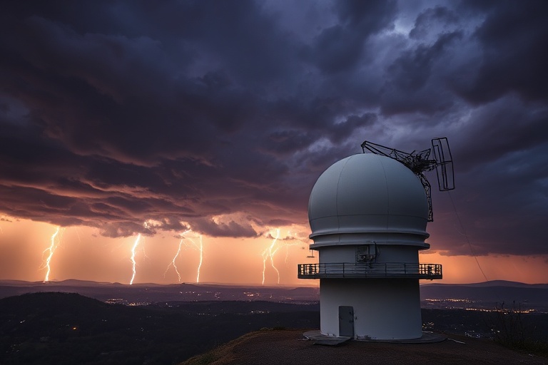
At its core, weather radar works by emitting pulses of microwave radiation that bounce off precipitation particles in the atmosphere. When these pulses return to the radar, the system calculates the time delay and intensity of the echoes to determine the location, movement, and intensity of rain, snow, or hail. Doppler radar, a more advanced version, measures the frequency shift of returning signals to assess wind speed and direction within storms.
Modern weather radars come in different types, each serving specific purposes:
- Doppler Radar: Tracks the motion of precipitation and wind, crucial for detecting tornadoes and severe thunderstorms.
- Polarimetric Radar: Differentiates between rain, snow, and hail by analyzing the shape and size of precipitation particles.
- Phased Array Radar: Uses electronic beam steering for faster updates, improving short-term forecasting.
- Space-Based Radar: Satellites like NASA’s Global Precipitation Measurement Mission provide global coverage, filling gaps in ground-based networks.
These technologies are constantly evolving. In Japan, researchers are developing radar systems capable of detecting typhoons three days before landfall, while European meteorologists use dual-polarization radars to improve flood warnings. The integration of artificial intelligence further enhances prediction accuracy by identifying patterns in vast datasets that human forecasters might miss.
Weather Radar in Global Cultures and Traditions
While weather radar is a modern scientific tool, humanity has always sought ways to predict the weather. Ancient civilizations relied on folklore, animal behavior, and celestial observations. In the Pacific Islands, navigators used the movement of clouds and ocean swells to anticipate storms before European explorers arrived. Today, these traditional methods coexist with radar technology, particularly in regions with limited access to advanced forecasting tools.
In India, farmers in rural areas often combine indigenous knowledge with weather radar data to plan agricultural activities. The monsoon season, critical for crops like rice and sugarcane, is monitored closely using both satellite imagery and local rainfall observations. Similarly, in the Andes, indigenous communities use changes in wind patterns and animal behavior to predict frost, a phenomenon that radar satellites are now helping to validate.
Culturally, weather radar has also influenced art and media. Storm-chasing documentaries, such as those featured on Entertainment networks, bring the drama of severe weather to audiences worldwide. Meanwhile, in Japan, anime and manga often depict characters using futuristic weather prediction devices, reflecting both fascination and anxiety about nature’s power. These cultural representations highlight humanity’s enduring relationship with the elements.
Challenges and Innovations in Weather Radar
Despite its advancements, weather radar faces several challenges. Urban areas with tall buildings can create “radar shadows,” where signals are blocked, leading to gaps in data coverage. Mountains and dense forests also interfere with radar beams, requiring creative solutions like placing radars on mountaintops or using mobile units for temporary coverage during emergencies.
Climate change is another factor complicating weather radar predictions. Increasingly intense storms and shifting weather patterns demand more adaptive systems. In response, scientists are developing next-generation radars with higher resolution and faster refresh rates. The U.S. National Weather Service, for example, is upgrading its network to dual-polarization radars, which provide better differentiation between precipitation types and improve flash flood warnings.
Another innovation is the use of crowd-sourced data. Apps and platforms allow individuals to report real-time weather conditions, supplementing radar data with ground truth observations. This approach is particularly valuable in developing countries where radar coverage is sparse. Projects like Weather Underground’s personal weather station network demonstrate how community participation can enhance global forecasting efforts.
The Future of Weather Radar
The future of weather radar lies in integration and accessibility. As technology becomes more affordable, smaller communities and even hobbyists can deploy personal weather stations, contributing to a denser data network. Advances in machine learning will further refine predictions, allowing for hyper-local forecasts that account for microclimates and urban heat islands.
Satellite constellations, such as those planned by private companies like Spire Global, aim to provide near-global coverage with frequent updates. These systems could revolutionize hurricane tracking and long-range weather forecasting. Meanwhile, in the Arctic and Antarctic, radars are being adapted to monitor melting ice and changing precipitation patterns, offering insights into climate change.
For the average person, weather radar is most visible through mobile apps and news broadcasts. These tools have transformed how we plan our daily lives, from choosing an umbrella to deciding whether to evacuate ahead of a hurricane. As climate-related disasters become more frequent, the role of weather radar in public safety will only grow in importance.
In the years ahead, expect to see weather radar embedded in smart home systems, autonomous vehicles, and even wearable devices. The line between weather prediction and daily convenience will continue to blur, making this technology an invisible but essential part of modern life.
A Final Perspective
Weather radar is more than just a tool for predicting rain—it’s a testament to human ingenuity and our relentless pursuit of understanding the natural world. From ancient farmers to cutting-edge scientists, our relationship with weather has evolved alongside technology. As we face the challenges of a changing climate, these systems will remain our first line of defense, reminding us that even in an age of satellites and AI, the sky still holds surprises.