How Weather Radar Works and Why It Matters Globally
“`html
Weather Radar: The Invisible Eye Tracking the Sky
Weather radar technology has quietly revolutionized how humanity anticipates atmospheric chaos. From the rice fields of Southeast Asia to the sprawling suburbs of North America, this invisible network of electromagnetic pulses provides the first warning before storms strike. Its development represents one of the most practical applications of physics in daily life, saving countless lives while reshaping agricultural, aviation, and urban planning decisions worldwide.
The Science Behind the Beams
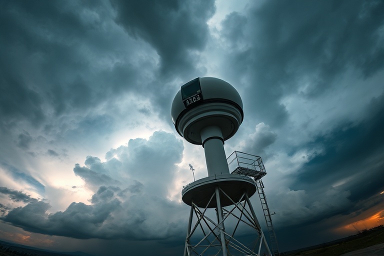
The principle behind weather radar is elegant in its simplicity. A transmitter sends out microwave pulses that bounce off water droplets, ice crystals, and other precipitation particles. When these pulses return, computers calculate the time delay and frequency shift to determine the distance, intensity, and movement of weather systems. Modern Doppler radar systems can even detect the rotational patterns that precede tornado formation, a capability that has transformed severe weather forecasting.
This technology evolved from military radar systems developed during World War II. Operators noticed that precipitation disrupted their signals, leading to accidental weather observations. By the 1950s, meteorologists had repurposed these systems for civilian use. Today, the United States operates the NEXRAD network of 160 WSR-88D radars, while Europe maintains its own sophisticated Meteoalarm system. Japan’s dense urban landscape requires particularly advanced radar networks to protect its cities from typhoons and torrential rains.
How Radar Data Becomes Public Knowledge
The transformation of raw radar data into actionable information involves several layers of processing:
- Data Collection: Radars scan the atmosphere every 4-10 minutes, with some advanced systems updating every 60-90 seconds during severe weather.
- Quality Control: Algorithms filter out non-precipitation echoes like birds, insects, and buildings that can create false returns.
- Analysis and Modeling: Supercomputers combine radar data with satellite imagery, weather balloons, and surface observations to create comprehensive forecasts.
- Dissemination: Government agencies and private weather services format this information for public consumption through apps, websites, and broadcast media.
Cultural Impact: When Radar Becomes Part of Daily Life
Weather radar has woven itself into the fabric of modern society in ways both obvious and subtle. In agricultural regions, farmers plan planting and harvesting around radar-based precipitation forecasts. In coastal communities, radar warnings dictate when fishing boats return to port before storms arrive. Even urban planning now considers radar coverage when siting emergency shelters and critical infrastructure.
The technology has also spawned its own visual language. The colorful radar loops that dominate weather broadcasts have become as familiar as stock market tickers. Weather apps now offer hour-by-hour precipitation forecasts with radar imagery that updates in real time. This constant access to atmospheric data has changed public expectations about weather preparedness.
In some cultures, traditional weather prediction methods have adapted alongside modern radar technology. In parts of rural India, farmers combine radar forecasts with observations of cloud patterns and animal behavior passed down through generations. Similarly, indigenous communities in Australia incorporate radar data into their seasonal calendars while maintaining traditional ecological knowledge systems.
The Economic Footprint of Radar Technology
The weather radar industry represents a significant economic sector, with the global weather forecasting services market valued at over $1.5 billion annually. This figure doesn’t include the broader economic benefits of accurate weather prediction, which the National Oceanic and Atmospheric Administration estimates at $31.5 billion per year in the United States alone through improved agricultural yields, reduced property damage, and enhanced aviation safety.
Commercial aviation relies heavily on radar data for flight planning and route optimization. Airlines use real-time radar information to avoid turbulence and severe weather, saving fuel while improving passenger comfort. The travel industry has similarly integrated radar data into itinerary planning, with cruise lines and tour operators adjusting schedules based on storm predictions.
Challenges and Future Directions
Despite its sophistication, weather radar technology faces several limitations. Radar beams can be blocked by mountains, creating blind spots in complex terrain. The curvature of the Earth limits radar range to about 230 miles for low-level precipitation detection. Urban areas with tall buildings also create interference patterns that complicate data interpretation.
Emerging solutions include phased-array radar systems that can scan the atmosphere electronically without mechanical rotation. These systems promise faster updates and greater flexibility in monitoring specific weather features. The next generation of weather satellites, particularly the GOES-R series operated by NOAA, provides complementary data that fills many radar gaps.
Climate change presents additional challenges. More intense precipitation events tax the resolution capabilities of existing radar networks. Warmer temperatures are shifting storm tracks northward in many regions, requiring adjustments to radar coverage priorities. Some experts advocate for expanding radar networks into currently under-monitored areas, particularly in developing nations vulnerable to extreme weather.
International Cooperation in Weather Monitoring
Weather knows no borders, and neither does radar technology. International cooperation in weather monitoring has reached unprecedented levels in recent decades. The World Meteorological Organization coordinates data sharing through its World Weather Watch program, which integrates radar networks from 193 member countries.
Some notable international radar collaborations include:
- The European Severe Weather Database, which aggregates data from 30 countries
- The Southeast Asian Radar Network that monitors typhoon activity across multiple nations
- The Antarctic Meteorological Research Center, which operates radars in some of Earth’s most remote locations
- The Global Precipitation Measurement mission, which combines radar data from satellites and ground stations worldwide
These cooperative efforts have been particularly crucial in regions prone to cross-border weather disasters. When Cyclone Amphan struck the Bay of Bengal in 2020, coordinated radar observations from India, Bangladesh, and Myanmar allowed for more effective evacuation planning and resource allocation.
A Look to the Future
The next frontier in weather radar technology involves artificial intelligence and machine learning. Researchers are developing algorithms that can predict storm intensification by analyzing subtle patterns in radar returns that human forecasters might miss. Some systems now use neural networks to automatically detect and classify different types of precipitation, from drizzle to hail.
Another promising development is the integration of radar data with other environmental sensors. Smart city initiatives in places like Singapore and Barcelona are combining radar observations with air quality monitors, traffic cameras, and IoT sensors to create comprehensive urban weather monitoring systems. These networks could eventually provide block-by-block weather forecasts that adapt to microclimates created by buildings and pavement.
The democratization of weather data represents perhaps the most significant trend. Open-source radar data platforms like the RadarScope app and the NOAA Weather API allow anyone with an internet connection to access raw radar data. Citizen science projects encourage weather enthusiasts to contribute observations and help verify radar interpretations, creating a distributed network of weather monitors.
As climate change intensifies weather patterns worldwide, the importance of reliable radar technology will only grow. The invisible beams that once helped farmers avoid afternoon thunderstorms now form the backbone of global disaster preparedness systems. From the rice terraces of Bali to the skyscrapers of New York, weather radar has become an indispensable tool for navigating an increasingly unpredictable atmosphere.
Looking ahead, the challenge will be ensuring that this technology remains accessible to all nations, not just those with advanced economies. The same radar beams that guide commercial airliners could one day provide early warnings for subsistence farmers in the Sahel or fishing communities in the Pacific Islands. In this way, weather radar serves as both a practical tool and a reminder of our shared vulnerability to the elements—and our shared capacity to understand and respond to them.